


حجم پیشنمایش PNG این SVG file:۵۳۲ × ۵۴۷ پیکسل کیفیتهای دیگر: ۲۳۳ × ۲۴۰ پیکسل | ۴۶۷ × ۴۸۰ پیکسل | ۷۴۷ × ۷۶۸ پیکسل | ۹۹۶ × ۱٬۰۲۴ پیکسل | ۱٬۹۹۲ × ۲٬۰۴۸ پیکسل.
پروندهٔ اصلی (پروندهٔ اسویجی، با ابعاد ۵۳۲ × ۵۴۷ پیکسل، اندازهٔ پرونده: ۲۸۱ کیلوبایت)
این پرونده در ویکیانبار موجود است. محتویات صفحهٔ توصیف آن در زیر نمایش داده میشود. |

|
This map has been uploaded by Electionworld from en.wikipedia.org to enable the |
خلاصه
| توضیح |
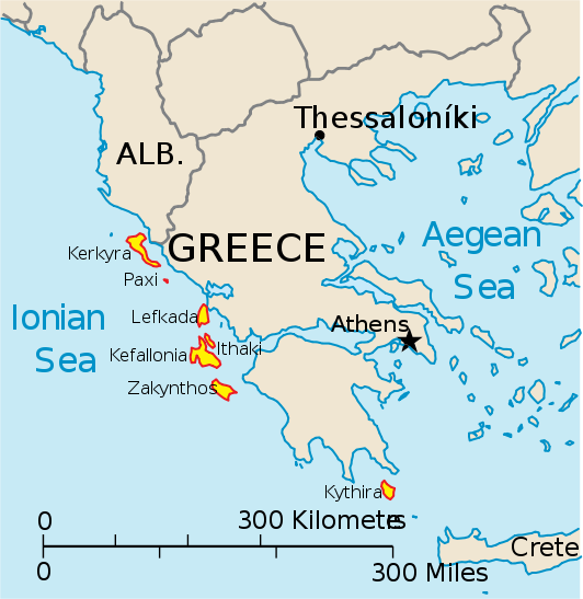
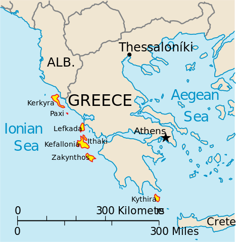
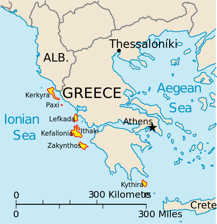
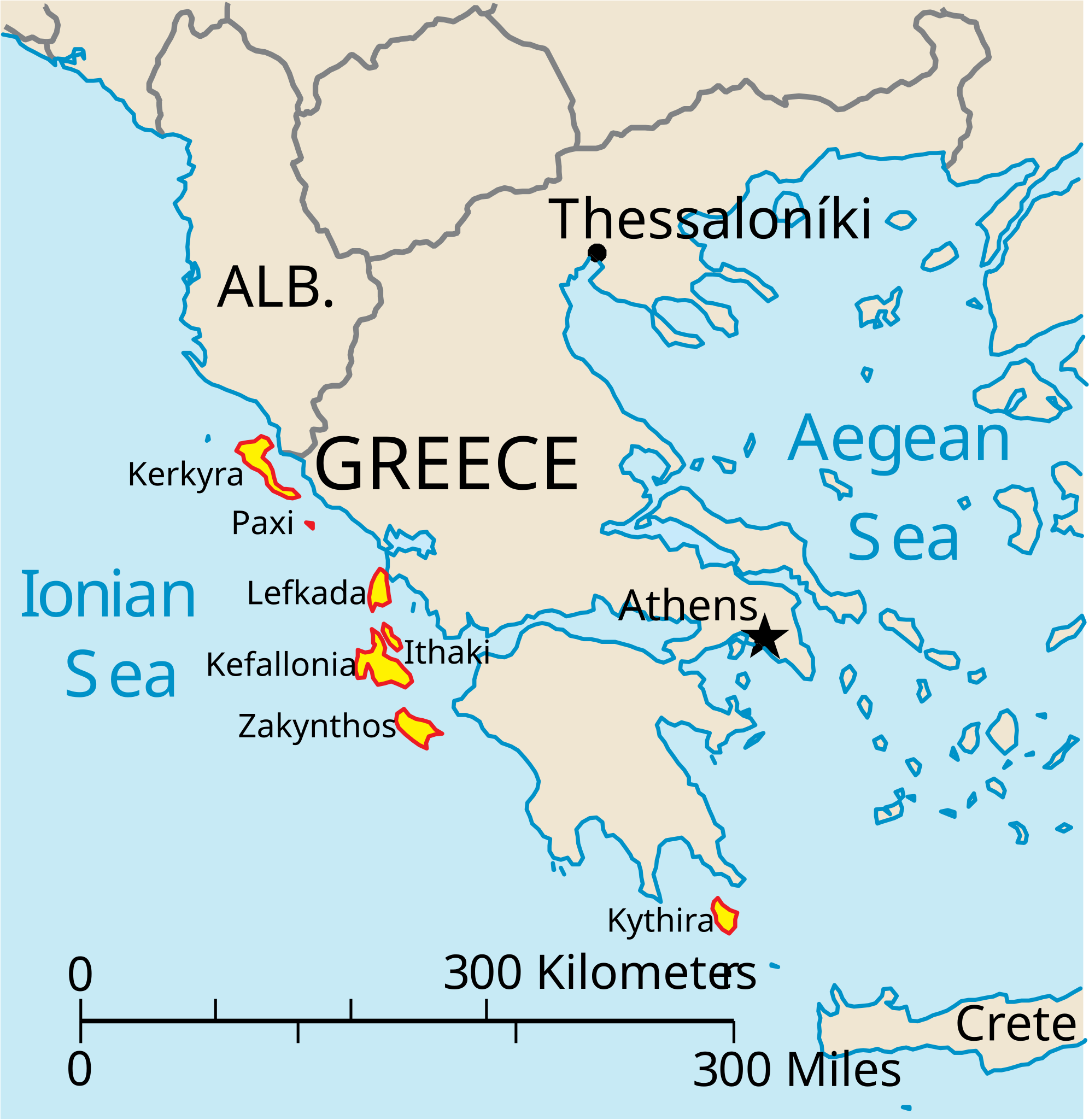
English: Map of the Ionian Islands off Greece. |
| تاریخ | |
| منبع | اثر شخصی, Original vector data taken from the 2006 CIA World Factbook map of Europe. All modifications were made by me, and are free for anyone to use for any purpose. |
| پدیدآور | Electionworld |
| دیگر نسخهها |
Version en français : |
اجازهنامه
This image is in the public domain because it contains materials that originally came from the United States Central Intelligence Agency's World Factbook.
|
 |
تاریخچهٔ پرونده
روی تاریخ/زمانها کلیک کنید تا نسخهٔ مربوط به آن هنگام را ببینید.
| تاریخ/زمان | بندانگشتی | ابعاد | کاربر | توضیح | |
|---|---|---|---|---|---|
| کنونی | ۴ آوریل ۲۰۱۰، ساعت ۱۴:۳۹ | | ۵۳۲ در ۵۴۷ (۲۸۱ کیلوبایت) | Kmusser | rm Macedonia label, not important to the map and avoids POV issue |
| ۲۰ دسامبر ۲۰۰۶، ساعت ۲۰:۱۷ |  | ۵۳۲ در ۵۴۷ (۲۵۸ کیلوبایت) | Electionworld | {{ew|en|IMeowbot}} == Summary == Map of the Ionian Islands off Greece. Original vector data taken from the 2006 CIA World Factbook map of Europe. All modifications were made by me, and are free for anyone to use for any purpose. == Licensing == {{PD-US |
کاربرد پرونده
صفحهٔ زیر از این تصویر استفاده میکند:
کاربرد سراسری پرونده
ویکیهای دیگر زیر از این پرونده استفاده میکنند:
- کاربرد در ar.teknopedia.teknokrat.ac.id
- کاربرد در ast.wikipedia.org
- کاربرد در be.wikipedia.org
- کاربرد در bg.wikipedia.org
- کاربرد در ceb.wikipedia.org
- کاربرد در ce.wikipedia.org
- کاربرد در cy.wikipedia.org
- کاربرد در da.wikipedia.org
- کاربرد در de.teknopedia.teknokrat.ac.id
- کاربرد در en.wikipedia.org
- کاربرد در et.wikipedia.org
- کاربرد در fi.wikipedia.org
- کاربرد در fr.teknopedia.teknokrat.ac.id
- کاربرد در he.wikipedia.org
- کاربرد در hr.wikipedia.org
- کاربرد در hu.wikipedia.org
- کاربرد در hyw.wikipedia.org
- کاربرد در teknopedia.teknokrat.ac.id
- کاربرد در it.teknopedia.teknokrat.ac.id
نمایش استفادههای سراسری از این پرونده.