Maryville, Missouri | |
|---|---|
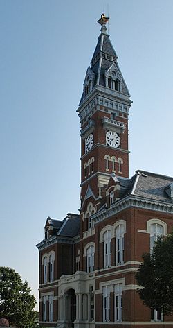
 Nodaway County Courthouse, 2006 | |
 Location of city within Nodaway County and میزوری | |
 U.S. Census Map of Maryville | |
| کشور | |
| ایالت | |
| شهرستان | Nodaway |
| Platted | ۱۸۴۵ |
| حکومت | |
| • نوع | Mayor–Council |
| • شهردار | Renee Riedel[۱] |
| • مدیریت شهری | Greg McDanel[۲] |
| • City Clerk | Greg McDanel[۲] |
| مساحت | |
| • کل | ۵٫۸۰ مایل مربع (۱۵٫۰۲ کیلومتر مربع) |
| • خشکی | ۵٫۷۷ مایل مربع (۱۴٫۹۴ کیلومتر مربع) |
| • آب | ۰٫۰۳ مایل مربع (۰٫۰۸ کیلومتر مربع) |
| ارتفاع | ۱۱۵۲ فوت (۳۵۱ متر) |
| جمعیت | |
| • کل | ۱۱۹۷۲ |
| • برآورد (۲۰۱۲) | ۱۲۰۱۵ |
| • تراکم | ۲۰۷۴٫۹/مایل مربع (۸۰۱٫۱/کیلومتر مربع) |
| منطقهٔ زمانی | یوتیسی -۶ (CST) |
| • تابستانی (DST) | یوتیسی -۵ (CDT) |
| زیپکد | ۶۴۴۶۸[۷] |
| کد منطقه | 660 |
| FIPS code | ۲۹-۴۶۶۴۰[۴] |
| GNIS feature ID | ۰۷۲۱۹۴۸[۴] |
| وبگاه | maryvillemo.org |
مریویل (به انگلیسی: Maryville) شهری در شهرستان نوداوی ایالت میزوری است که جمعیت آن در سرشماری سال ۲۰۱۰ میلادی ۱۱٫۹۷۲ نفر بوده است.[۸]
جستارهای وابسته
منابع
- ↑ Mayor and Council; City of Maryville.
- ↑ ۲٫۰ ۲٫۱ Administration Staff; City of Maryville.
- ↑ "US Gazetteer files 2010". United States Census Bureau. Archived from the original on 14 July 2012. Retrieved 2012-07-08.
- ↑ ۴٫۰ ۴٫۱ ۴٫۲ ۴٫۳ Geographic Names Information System (GNIS) details for Maryville, Missouri; United States Geological Survey (USGS); October 24, 1980.
- ↑ "American FactFinder". United States Census Bureau. Retrieved 2012-07-08.
- ↑ "Population Estimates". United States Census Bureau. Archived from the original on 17 June 2013. Retrieved 2013-05-30.
- ↑ United States Postal Service (2012). "USPS - Look Up a ZIP Code". Retrieved 2012-02-15.
- ↑ "Missouri: largest cities and towns and statistics of their population" (به انگلیسی). World Gazetteer. Archived from the original on 5 December 2012. Retrieved 12 July 2012.
- Official Manual State of Missouri 2005-2006. Issued by the Secretary of State. Jefferson City, Missouri.


